


UNION SOUTH Voting District, Ross County, Ohio
About
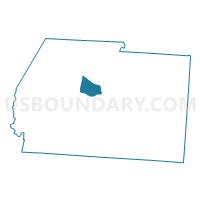
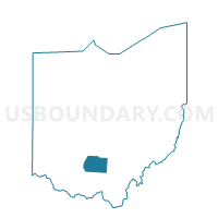
Outline

Summary
| Unique Area Identifier | 651378 |
| Name | UNION SOUTH Voting District |
| County | Ross County |
| State | Ohio |
| Area (square miles) | 9.22 |
| Land Area (square miles) | 9.22 |
| Water Area (square miles) | 0.01 |
| % of Land Area | 99.92 |
| % of Water Area | 0.08 |
| Latitude of the Internal Point | 39.37869250 |
| Longtitude of the Internal Point | -83.10958270 |
Maps

Graphs
Select a template below for downloading or customizing gragh for UNION SOUTH Voting District, Ross County, Ohio


Neighbors
Neighoring Voting District (by Name) Neighboring Voting District on the Map
- CONCORD FRANK PREC Voting District, Ross County, OH
- CONCORD ROXABELL Voting District, Ross County, OH
- TWIN EAST Voting District, Ross County, OH
- TWIN NORTH Voting District, Ross County, OH
- UNION EAST Voting District, Ross County, OH
- UNION PV Voting District, Ross County, OH
- UNION WEST Voting District, Ross County, OH
Top 10 Neighboring County Subdivision (by Population) Neighboring County Subdivision on the Map
- Union township, Ross County, OH (13,345)
- Concord township, Ross County, OH (4,460)
- Twin township, Ross County, OH (3,384)
Top 10 Neighboring Unified School District (by Population) Neighboring Unified School District on the Map
- Union-Scioto Local School District, OH (16,338)
- Adena Local School District, OH (6,726)
- Paint Valley Local School District, OH (6,119)